


Updated 2:53 p.m.: Several central Oklahoma counties removed from Tornado Watch

The National Weather Service has removed Payne, Lincoln, Logan, Oklahoma, Canadian, Caddo, Kiowa, Jackson, and Hardeman counties from the Tornado Watch issued earlier Saturday.
A Flash Flood Warning remains in effect until 4:30 p.m. Meteorologists say the next batch of heavy rain should arrive in central Oklahoma around 4 p.m. Spotters on amateur radio reported flooding covering U.S. Highway 81 north about 11 miles north of Chickasha.
235pm-Ponding, minor slow drainage on #OKC freeways and roads with some impact on traffic. Drive with caution. Beware of flash floods. #okwx
— City of OKC (@cityofokc) May 9, 2015
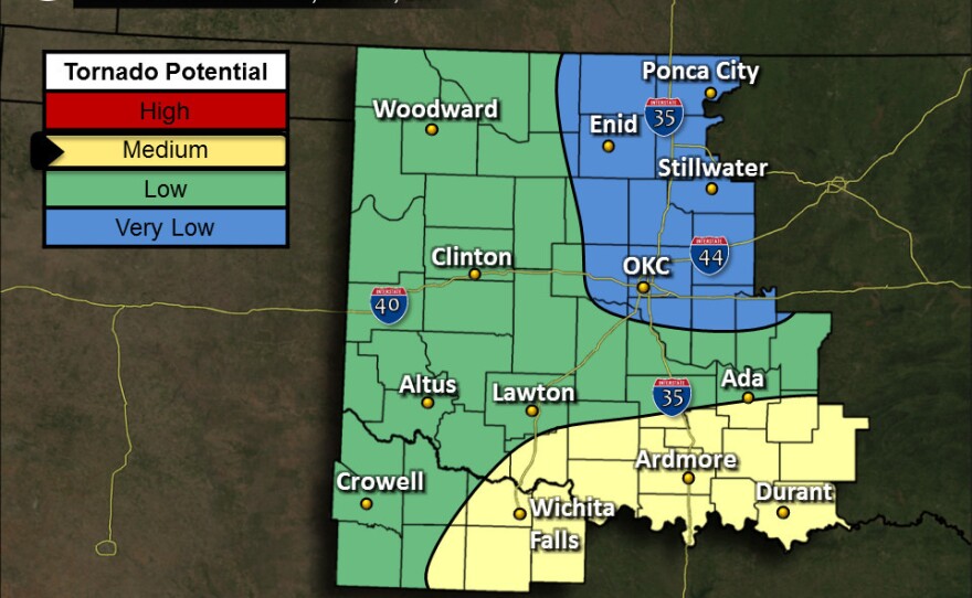
Updated 1:28 p.m.: Tornado Watch issued for central, southwest Oklahoma, Flash Flood Warning for Oklahoma City metro
The National Weather Service has issued a Tornado Watch until 9 p.m. that includes the Oklahoma City metro. Severe storms over southwest Oklahoma are intensifying as they move northeast.
Sorry OKC metro. More storms inbound. More flooding, too. Stay alert! Tornado watch now in effect! #okwx
— Rick Smith (@ounwcm) May 9, 2015
Breaks in the clouds early Saturday afternoon in southwest Oklahoma allowed the sun to warm the air, creating atmospheric instability that could spawn several more severe thunderstorms.
A Flash Flood Warninghas also been issued for counties in central Oklahoma until 4:30 p.m. One to two inches of rain could fall per hour with this storm moving into the metro, and much of the area has received between five to ten inches of rain since Wednesday. The already saturated ground will quickly flood in areas that get more rain.

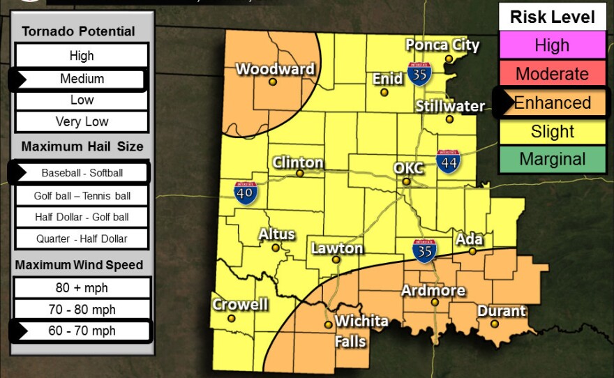
Updated 12:31 p.m.: Oklahoma City area under Enhanced Risk
The Norman Forecast Office of the National Weather Service now says the area with the best chance for tornadoes has moved south into parts of southern Oklahoma and north Texas. But Oklahoma City is once again under an enhanced risk for hail up to the size of softballs, 70 mile-per-hour winds, and possibly tornadoes.
"As of right now, it looks like the tornado potential will be the highest this afternoon and evening over parts of western North Texas and southern Oklahoma," says Warning Coordination Meteorologist Rick Smith. "It's a very, very complex scenario this afternoon. The weather is going to be changing quickly. We're going to have multiple rounds of thunderstorms affecting areas, and we can't forget about that flash flooding threat."
1235pm - breaks in clouds over SW OK have allowed air mass to become more unstable. Storms developing and moving NE need to watched! #okwx
— Rick Smith (@ounwcm) May 9, 2015
The elevated risk area for tornadoes includes Lawton, Duncan, Ardmore, Madill, and Durant, as well as Wichita Falls, Henrietta, and Archer City, Texas.
Emergency managers in Minco and Altus have activated emergency operations centers in those cities, and trained storm spotters are watching several thunderstorms moving through southern and western portions of the state. Dime-sized hail has been reported near Cyril.
Updated 11:59 a.m.: Severe Thunderstorm Watch expanded into central Oklahoma

The National Weather Service has expanded the Severe Thunderstorm Watch to include the Oklahoma City metro, as well as counties along the Red River and the Texas border.
A Severe Thunderstorm Warningis also in effect for Lawton and the southwestern most corner of Grady County.
Updated 8:37 a.m.: Northwest Oklahoma no longer under moderate risk, Severe Thunderstorm watch issued
The latest outlook from the Storm Prediction Center in Norman has taken northwest Oklahoma out of the moderate risk area for severe weather. Most of the state is still under an enhanced or a slight risk.
Trying to answer several questions in this one post: no tornado threat in the OKC metro with morning storms. Chances increase later today.
— NWS Norman (@NWSNorman) May 9, 2015
Early Saturday morning the National Weather Service also issued a Severe Thunderstorm Watch for much of western and southwest Oklahoma. Most cities in central Oklahoma will not be testing outdoor warning sirens Saturday.
Original Post
National Weather Service meteorologists say strong to severe storms are possible again this weekend, although the threat of a significant tornado outbreak appears to have shifted to the west.
Forecasters say the situation is complex and could evolve rapidly, but as of Saturday morning the moderate risk area of severe storms includes the northwest corner of the state, including the Woodward area. Central Oklahoma is still under a slight risk.
Have plans this morning or early afternoon? Storms likely from western through central OK 8 am through 1 pm. #okwx #texomawx
— NWS Norman (@NWSNorman) May 9, 2015
A round of storms currently moving through southwest Oklahoma and western North Texas could arrive at Interstate 35 between 9 and 10 a.m.
There's a possibility of an early round of storms Saturday morning that could bring hail, straight line winds, and heavy rainfall, with a second, more significant wave across northwest Oklahoma Saturday afternoon and early evening. Storms that develop later have a much higher tornado potential. The afternoon round of storms depends on the timing and duration of Saturday morning's first wave.
In a Facebook post, the Norman Forecast Office said If the earlier wave of storms moves out sufficiently early, a more widespread and pronounced severe threat may evolve across western Oklahoma. Any storm that persists into the evening hours will find itself in an environment supportive of strong tornadoes.
Most metro school districts have canceled activities due to the threat of severe weather this weekend. The University of Oklahoma canceled Friday night's commencement ceremony, but individual college convocations will proceed as planned. At Oklahoma State University in Stillwater, the times of three convocations inside Gallagher-Iba Arena have been changed.
- 8 a.m. -- College of Education, College of Arts & Sciences
- 11 a.m. -- College of Human Sciences, College of Engineering, Architecture & Technology
- 1:30 p.m. -- College of Agricultural Sciences & Natural Resources, Spears School of Business
The 7 p.m. OSU Graduate College commencement will proceed as planned. Meteorologists are concerned that many out-of-town travelers for graduation ceremonies and the Mother's Day holiday may not understand severe weather precautions and terminology as well as Oklahoma residents.
As a cold front starts to move into the area Sunday, there could be more severe storms, bringing more heavy rainfall. Large hail and damaging winds are possible, and there's also a low threat of tornadoes.

The Flood Watch has been extended to 7 a.m. Monday. Some Oklahoma Mesonet sites have received anywhere from 7 to 10 inches of rain since the first round of severe storms Wednesday, meaning rivers, ditches, and low spots in the roadway could quickly flood because the already saturated ground can't absorb much more water.
----------------------------------------------
KGOU is a community-supported news organization and relies on contributions from readers and listeners to fulfill its mission of public service to Oklahoma and beyond. Donate online, or by contacting our Membership department.


